What is the cause for the degradation of environment?
Capitalism, corruption, consuming society? - OVERPOPULATION!
Please, save the Planet - kill yourself...

Showing posts with label environment. Show all posts

Friday, September 23, 2016

Environmental Monitoring App

Python, R, Qt, peewee, bokeh, pandas, SQLite plus couple of sleepless nights and here you are a сute app for the environmental monitoring needs )))
Main window of the application

Thursday, March 26, 2015

Why are natural environments often degraded in the name of economic progress even when this invites disaster, and how can this be overcome?

This was one of discussion questions of the Disasters and Ecosystems MOOC.

Actually the answer is simple. The formula for successful environmental degradation consists of 2 variables - overpopulation and capitalism.

When there are a lot of people - most of them a poor, uneducated and hungry. When you are hungry you will do everything to become less hungry today even if it can potentially lead to negative consequences tomorrow, which you may not even foresee if you are uneducated.

Humans are good in adaptation. When the adaptation is strong enough it leads to abuse (for example, if you are well adopted at the stock market you start abusing it to increase your profit even if it will cost dearly to the other stakeholders - people value their own well-being much more than the other's and of course much more than the well-being of environment especially when they know that their own impact seems negligible compared to impact of the entire population).  When you live in condition of free market of capitalistic world - you are your only hope for not being hungry (or being more wealthy) now. And as you know from the economic theory - the capitalist economy needs a constant grows of consumption and production - so you need more and more resources to just sustain the economy. In conditions of capitalist market people value today's profit much more than losses of tomorrow.

You see - the capitalist economy needs people to consume more and more; more people - more consumption; more people - more poverty and lack of education; more hungry uneducated people people - more people willing to do anything to survive now and don't even bother themselves about the future.

Overpopulation and a consumption society (created by capitalist economy) inter-stimulate each other and destroy the environment for the today's profits or food and doesn't care much of the consequences of tomorrow because most are either uneducated or doesn't care at all plus you have to live through today to face consequences of your actions tomorrow (a day-by-day living).

Obviously there are 3 steps to improve the situation:
  • Decrease the population.
  • Educate people.
  • Create new sustainable economy model that would equally value tomorrow's losses and today's profits, and would not rely on constantly increasing consumption.

Saturday, January 17, 2015

Disasters: Myth or the Reality?

I enrolled a MOOC titled "Disasters and Ecosystems: Resilience in a Changing Climate" which is organised by the UNEP (and other organisations... which names I'm going to learn by heart cause they have like 2 minutes of credits after each lecture O_o ). Not that I know nothing about disasters, risks or climate change (I'm a geographer and ecologist after all), but I was curious about the product that was made by organisation of this class.

The third video (and first video that is not an introduction) they teach us about the disasters; differences between hazard and disaster; and risks. Well... the thing they told, the graphs they showed - that what inspired the title of this post.

Terminology

Here see some definitions they use.

Disaster. When they say "disaster" they mean "natural disaster" that was enhanced by human [mismanagement].

Risk - a potential losses due to disasters.

Hazard - A dangerous phenomenon, substance, human activity or condition that may cause loss of life, injury or other health impacts, property damage, loss of livelihoods and services, social and economic disruption, or environmental damage.

Exposure - People, property, systems, or other elements present in hazard zones that are thereby subject to potential losses.

Vulnerability - the characteristics and circumstances of a community, system or asset that make it susceptible to the damaging effects of a hazard

Fails

The risk

They presented a "great" formula for (a disaster) risk evaluation that they use in the UN:
Risk = Hazard * Exposure * Vulnerability
where: Exposure = People * ExposureTime
Vulnarability - succeptability to hazard.
Well these characteristics do correspond to the risk, but the formula is stupid! I already wrote about that: Risk = Probability * Damage. And this formula actually corresponds to the definition they give (see Terminology section). We can't get a monetary outcome from their formula. We can't get numeric numeric output out of that formula at all: can you multiply flood by people? Can you???!!!

A Disaster with Disasters

The fail with the risk evaluation is a common mistake, but the fail with disaster - that is what really cool!

Take a look at this plot (which is from reading materials from the course):
What can you conclude from this plot? That the world is doing to hell and we all will fall to disaster? Let's look closer. The exposure is growing faster for poorer countries (and it is the only conclusion they make in lecture)... but the total number of people exposed (and for each type of countries) seems to be the almost unchanged! Interesting... This means (see the definition for the exposure) that there are just a 150% increase of property value in the dangerous area of the poorer countries (and 25% for the richest) on a span of 30 years. Does this graph shows us only the economic grows? I think it does... (reminds me of my previous post).

Now to the most delicious part. Take a look at this two graphs from the lecture readings:

Deaths dynamics


Damage dynamics

This is interesting. Despite the population growth and all that questionable "climate change" staff people die less (in total numbers), see fig. 1, but the damage increases, see fig. 2. Did they take inflation into account for the damage graph? Do not know... I think they didn't, otherwise they would use "discounted damage" term instead of just "damage" and would indicate the base year. So the second graph seems to demonstrate inflation and may be the economic grows.

Clearly disasters are not that disastrous. Despite the new on the TV on the subject the nature's wrath even enhanced by human is less and less dangerous for human lives. The pockets are to suffer: the storm in port wrecking the humble fisherman's boat or a trawler - that's the difference.


Conclusion

From these graphs I can conclude one thing - it is safer to live now than in the past, a disaster should not be feared as a deadly havoc. To my mind the disaster nowadays is entirely economic issue. See, if we loose less people and (maybe) more money - we should just develop more advanced insurance techniques to cover economic damage and relax. The disasters should just be studied as phenomena to develop cheap early warning systems, let the property be destroyed (just cover the losses with insurance) and additional employment to be created (rebuilding).

This is my conclusion form the graphs I showed here: disasters are an ancient myth! Just buy insurance! LOL

Monday, September 8, 2014

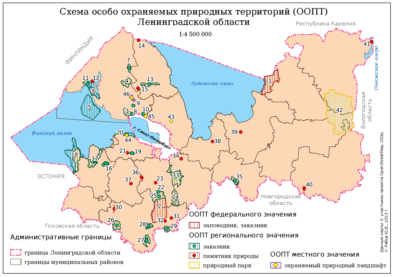
Schema of the Conservation Areas in Leningradskaya Region: Some Notes for Beginner Mappers

Schema of the Conservation Areas in Leningradskaya Region

About a year ago I was asked to create a small (a B5 size) and simple schema of the conservation areas in Leningradskaya region. I did it using QGIS. Here you are the author version of the schema and several notes that might be helpful for a beginner map-maker.

There was a huge disproportion between areas of different objects and both polygon and point markers were needed to show them. I decided to use Centroid Fill option in polygon style to be able to use only one layer (polygon) instead of two (polygon and point). Using Centroid Fill makes points in centres of the small polygons overlap and mask these tiny polygons. 

All the administrative borers were stored in one layer (and there are far more borders than one see here). They are drawn using rule-based symbology so I didn't even need to subset this layer to get rid of the rest of the polygons in this layer.

All the names of the surrounding countries, regions, city and the water bodies are not labels derived from layers, but labels created inside the map composer. It was quicker and their position was more precise which is crucial for such a small schema.

There was a lack of space for the legend so I had to utilise every bit of canvas to place it. I had to use 3 legend items here. One of them is actually overlapping the other and setting a transparent background for the legends was helping with that.

Finally labels for the conservation areas (numbers) were outlined with white colour to be perfectly readable. Some of them were moved manually (with storing coordinates in special columns of the layer) to prevent overlapping with other labels and data.

P.S. Don't be afraid to argue with the client about the workflow. Initially I was asked it manually digitise a 20 000 x 15 000 pixels raster map of the Leningrad region to extract the most precise borders of the conservation areas (and districts of the region). Of course I could do it and charge more money for the job, but what's the point if some of that borders are not even to be seen at this small schema? So I convinced client to use data from OSM and saved myself a lot of time.

Sunday, October 21, 2012

Fire Dynamics In Leningrad Region in 2006

Today I decided to play with TimeManager plugin for QGIS that was introduced by underdark some time ago. After some search across my spatial storage I found only one dataset that contained timestamps: FIRMS fire data that I used for creation of a methodology for burn-out probability calculation (for illegal dumping environmental risk assessment) and for assessment of human influence on fire starting.


Seems that TimeManager is not quite stable after the certain number of features in layer. At least on my machine it crushed several times (during slider manipulation) on the whole dataset of about 7000 points but worked just fine with its one-year subset of about 2700 points. But anyway overall impression is very good.

The main issue was to create a video from the generated .png files. I used console ffmpeg utils. Simple command:
:~>  ffmpeg -r 1/1 -i frame%03d.PNG -vcodec yuv420p -video_size 1126x560 output.flv
produced a 3-minute video above. One second corresponds to 1 day of the most  flammable year for the Leninngrad region in a decade. Video covers period from April to November 2006. I was too lazy to create custom undercover and just loaded OSM via OpenLayers plugin)))

Wednesday, August 1, 2012

Sverdlovskaya Region, Russia: a Field Survey in Autumn. Part 2: Scars on the Earth

Ok, it's time to finish the story about land monitoring in Sverdlovskaya region. In this post I would like to demonstrate some of the most unpleasant types of the land use.

Lets begin with illegal dumping. This dump (note that there is the smoke from waste burning down) is located right next to the potato field (mmm... seems these  potato are tasty). The ground was intentionally excavated here for dumping waste. Obviously this dump is exploited by the agricultural firm - owner of this land, but who cares...
Panorama of freshly burnt illegal dump

The next stop is peat cutting. A huge biotops are destroyed for no good reason (I can't agree that use of peat as an energy source is a good one). At the picture below you can see a peat cutting with the area of 1402 ha. There are dozen of them in the study area...
Peat Cutting (RapidEye, natural colours)
But the most ugly scars on the Earth surface are left from mining works. There is Asbestos town in Sverdlovskaya region. It was names after asbestos that is mined  there. The quarry has an area of 1470 ha and its depth is over 400 meters. Its slag-heaps covers another 2500 ha... The irony is that this quarry gives a job for this town and killing it. You see, if you wand to dig dipper you have to make quarry wider accordingly. Current depth is 450 m and in projects it is over 900 m, but the quarry is already next to the living buildings. So quarry is going to consume the town... By the way, the local cemetery was already consumed. Guess what happened to human remains? Well, it is Russia, so they were dumped into the nearest slug-heap.

Here is the panorama of the quarry. You may try to locate BelAZ trucks down there ;-)
Asbestos quarry
Here is the part of the biggest slag-heap:
A slag-heap
That's how it looks from space:
Asbestos town area (imagery - RapidEye, NIR-G-B pseudo-colour composition)
And in the end I will show you the very basic schema of disturbed land in the study area (no settlements or roads included). Terrifying isn't it? 

Basic schema of disturbed land 

Monday, April 23, 2012

Illegal Dumping in Leningrad Region: Press Conference

There was a press conference on Tuesday the 19-th about illegal dumping in Leningrad region (Russia). I was asked to be the main speaker there and to present to the press my recent study on illegal dumping prevention. I've already had two presentations on this subject recently at the international scientific conference in St. Petersburg State University and at the round table for the discussion of the upcoming "Let's do it. Russia" clean up event.

Some video from the press conference:


The main conclusion that I made by investigating possible impacts on illegal dumping prevention (such as penalty increase, chance of being caught increase and waste disposal fare decrease) is that decrease of the waste disposal fare for population is the most efficient way. And I managed to find two other publications that came to the exact conclusion (for example, there is an evidence that 1% waste fare increase leads to 3% increase of illegal dumping cases).

By the way I was able to assess probability of being caught for illegal dumping in Russia. It is about 10-5 (you can die while playing soccer with such probability).

The only way to reduce waste fares is to use waste as a resource. That means that the only way to prevent illegal dumping is to create waste management system that would be able to complete the zero waste goal.

And here is an abstract from my article:

Mechanisms of the land protection were discussed in this article. An algorithm of decision making whether to dump illegally or not was explained. Formulas for determination of profitable ration of expenditures per unit and amount of illegally dumping waste are substantiated. Effect from different types of impacts that can be used for land protection from illegal dumping were discussed (such as fares change, penalties change, penalty application probability change). Decreasing of waste disposal fares was acknowledged as the most effective way for illegal dumping prevention, but it is possible only if «zero waste» concept is implemented.

Tuesday, April 3, 2012

Universal Ecolabeling: an "eco-Black-Spot" concept

Nowadays  more and more people cares about environmental-friendly goods. Ecolabeling is often used to distinguish such goods from regular goods. 

But there are several issues:
  • there are a lot of ecolabels, provided by different organisations with different standards so quality of the given ecolabel usually is uncertain;
  • ecolabels are difficult to recognize: if you unaware about given ecolabel and know nothing about authority, that gave it - you are likely to miss the point that this is ecolabel, or even you can be tricked by companies with some green-coloured sign with a word "eco", this leads us to the following point -
  • often they can't be trusted - companies like to place their own labels that states that product is friendly to environment to attract customers, but these labels are just a trick and has nothing to do with reality.
So I would like to propose another approach. Do you remember BP re-branding after  Deepwater Horizon explosion and infamous oil spill? I hope you do. What if we will oblige companies to put negative labels on the products which production causes significant threat to environment?! - A universal "eco-Black-Spot" for environment abusers!

Pros: 
  • we won't need external sertification organisation to confirm that this company deserves an eco-Black-Spot - an environmental agencies already have the necessary information;
  • nobody will forge eco-Black-Spot for their goods;
  • forged (self-made) "ecolabels" will instantly fail being alongside with the eco-Black-Spot.
  • companies will try to wipe out an eco-Black-Spot from their products by actual contribution for preservation of the environment.
Cons:
  • m-m-m... I don't see any. Do you?
And what about design of the eco-Black-Spot? I believe it will be convenient to use something like this:
or this:


Friday, February 17, 2012

About Environmental Risk Assessment

There was a scientific seminar dedicated to environmental risks assessment in the scientific-research centre where I work. A speaker was awfully ignorant in subject unfortunately. As a person who is experienced in environmental risk assessment (see my posts about risks and a particular methodology) I was afraid that I will be the one to ask the speaker (quite an old man) some inconvenient question about formulas he used, but luckily he was ashamed by someone else.

During the discussion the question of monetary aspect of the risk and damage to environment was raised: whether it is possible to use money as the measure of risks that only applicable to environment itself. In other words: is it rational to use money when assessing possible damage to solely ecosystem (there are no money in ecosystem by itself), and how to perform such assessment?

What do YOU think? I wasn't able to find an appropriate answer at that moment, but now I believe I have a point. My answer is YES, we can use money to assess risks and damage dealt to ecosystem only.

Firstly the assessment is made by humans and for humans. And humans understand monetised value more easily. The approach that I want to propose is about assessment of money that have to be spent to recover ecosystem to exact the same state it was prior to caused or possible damage. Just imagine how much money one have to spent for recreating and reintroduction of just one extinguished species (a tasmanian wolf for example). Here you are a monetised damage to environment.

Another approach I have in mind is about evaluation of risks via relative live value of species (which can be easily monetised too). Lets use this formula for evaluation of life of individual of a given species: V=(1/N)*P, where V - relative value, N - population of the given species (or given areal of species), P - total population of the human beings. We will have a relative value as 1 for humans and 1*(P/N) for a given species. For example for a tiger we will have its relative individual value about 1 076 900! Literally, if we have a choice whether to save 1 million people or a single tiger, the tiger must be saved - not a million of people!!!

And we can monetise this value by multiplication on the average value of the single human life (you can play a bit with numbers given here).

So the damage to ecosystem may be assessed via loss of number of individuals of species that live in a given ecosystem and we are able to easily evaluate a relative value of the individuals of the each species, and it can be easyly monetised.

Saturday, December 10, 2011

Interactive Round Table on Separate Waste Collection in St. Petersburg, Russia

The other day I took part in a very interesting event - an interactive round table on a separate waste collection in the city (En), that was organized by Musora.Bolshe.Net (Waste.No.More) NGO. There were representatives of the St. Petersburg city administration, waste treatment companies, hotel business, cleaning companies, NGOs, mass media and science (a humble me).

It was great that there were no presentations from the experts, etc. The main point was the direct and open discussions (of course it was moderated) about the existing issues and challenges in the field of separate waste collection and recycling and the ways to solve them.

The second part of event was a development of waste related projects in small groups. Every one took part in development 3 projects and the group members were different each time. Of course the plans itself are quite useless: what kind of plan can be developed in 15 minuets? But the shearing of knowledge and opinions with others and development of the common view at the issue helps to get new ideas. 

I was lucky to work in the same teams with representatives of the city committees. Unfortunately they are not open-minded enough and I think they do not fully understand the main economical and legislation obstacles that prevents separate waste collection or not motivated enough to overcome it. But seems that they are not hopeless.

It was very interesting to discover that many people are interested in (speaking professional language) GIS-portal dedicated to shearing information about locations of relatively small amount of recyclables, that will let waste producers and recyclers find each other for the common benefit. So if you were looking for ideas for a start-up or expanding of your GIS-business - here you are ;-) Seems that I should develop my web-GIS skills...

Monday, November 28, 2011

Sverdlovskaya Region, Russia: a Field Survey in Autumn (Part 1)

While every normal environmental scientists perform their field surveys in Summer (unless there is a need to do this in a specific time of the year) I had to do mine when the weather was not that good. In a five days my colleague and I had to collect land monitoring archives of 3 districts of Sverdlovskaya region, soil samples for analysis for heavy metals concentrations and take pictures of the disturbed lands.


Hit the "read more" button to read the rest of the story...

Friday, September 2, 2011

Responsibility of Scientists in Climate Change "Issue"

At the the last week I've spent 5 days amongst Baltic Sea related scientists (there were almost 600 of them) at 8-th Baltic Sea Scientific Congress. The congress was interesting indeed even if I'm not a marine or meteorological scientist. There were a plenty of presentations on climate, winds, curves, salinity modelling, environmental risk assessment and governance (a lot of scientists do have problems with risk assessment). And I had a poster about illegal dumping monitoring.

But I would like to show you the presentation of Hans von Storch about "Knowledge generation vs. decision processes - the issue of regional climate service" which I liked the most. It concerns responsibility of the scientists for the knowledge they provide.  Let me start from the end of the presentation and if you will find yourself interested in further reading - hit the "read more" button. All pictures are clickable.


Sunday, August 7, 2011

Climate Change: Mass Killing - Simple And With Impunity

"I have severe doubts that we can support even two billion if they all live like citizens of the U.S. The world can support a lot more vegetarian saints than Hummer-driving idiots."
~ Paul Ehrlich

There is an interesting post about estimated amount of years for each country to cease their green house gases emission. Most of the countries have to do it in the following 10 years... And there are loud words about "climate racism" and "climate genocide" with reference to some Climate Genocide. They asseverate that
"Both Dr James Lovelock FRS (Gaia hypothesis) and Professor Kevin Anderson ( Director, Tyndall Centre for Climate Change Research, University of Manchester, UK) have recently estimated that only about 0.5 billion people will survive this century due to unaddressed, man-made global warming. Noting that the world population is expected to reach 9.5 billion by 2050, these estimates translate to a Climate Genocide involving deaths of about 10 billion people this century, mostly non-Europeans, this including about 6 billion under-5 year old infants, 3 billion Muslims in a terminal Muslim Holocaust, 2 billion Indians, 1.3 billion non-Arab Africans, 0.5 billion Bengalis, 0.3 billion Pakistanis and 0.3 billion Bangladeshis. Already 18 million people die avoidably every year in Developing countries (minus China) due to deprivation and deprivation-exacerbated disease and man-made global warming is already clearly worsening this global avoidable mortality holocaust. However 10 billion avoidable deaths due to global warming this century will yield an average global annual avoidable death rate of 100 million per year"
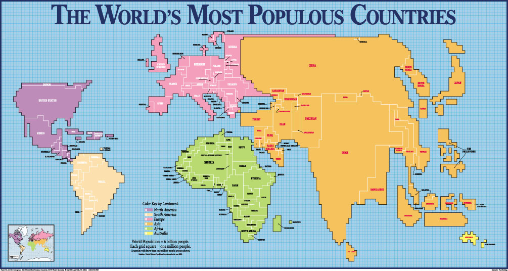
...errr... SO WHAT?!!!... Look around guys! There are more than 7 billions of us at this poor planet and we are consuming it. More people means need of more resources for food, more fields, more coffins. There is an OVERPOPULATION and you don't have to be genius to notice it! If so called Global Warming or Climate Change will lead to major human population decrease than it's a blessing, not a blight!

Again: "...Climate Genocide involving deaths of about 10 billion people this century, mostly non-Europeans...". Of course most of them won't be Europeans! Look at the map (taken form here):
Most Populous Countries

Then take a look at this graph (taken from here):
World Population Growth for Developing and Industrialised Regions
Who is responsible for overpopulation? - Developing countries... I assume that it would be not fare if "..the most of them would be Europeans..." If by the end of the century there will only 0.5 billion people remain, than we will just fit to our planet's capacity for the humans (taking into account that some of us consume more than others).

Back to the so called climate change. I'm environmentalist, so I'm pleased that there are a lot of activities about ceasing of the green house gases emission. But on the other hand I'm scientist, not a climate scientist, but environmental one (I'm ecologist and geographer), so I my opinion is that CO2 is not the threat we must fight with. I have some scientific subscriptions and it is always painful for me to see that the major part of the world's environment research are dedicated to this "problem" of climate change. People could do the real job, but it is easier to find founding for the "climate change" research... A fellow misanthrope wrote a nice post about this political game. And you should see the video on that page.

Finally here you are another site of an open-minded person about overpopulation (with some awesome quotes by the way).

P.S. Now I wonder whether I should turn off my computer at night or not... Seems that in the long term it will be better for environment to let it work ;-)

Saturday, August 6, 2011

About Risks

I'm looking for the approaches for the environmental risks estimation at the given area. I have my own ideas for the current task, but it is always interesting to know what other people do.

Today I acquainted myself with a master thesis on a subject of spatial analysis of epidemiology of some disease. I was curious because it was about risk mapping. But I was totally disappointed. The guy didn't mention the definition for the "risk" term he used and it is quite obvious why. Instead of the risk assessment (which implies monetary estimation of the probability of undesired event) he estimated the probability of contracting disease... The thesis is good actually, but the guy did much lesser job than one should when he studies risks.

The same shit exists in Russian legislation. It defines "environmental risk" only as s probability of event that harms environment. So for example if I'm studying risks of the fire at illegal dumps then I can assess just a probability of such events at the given region and don't bother myself with possible damage estimation...

Remember: [Risk] = [Probability] * [Damage]. If you do not estimate damage - you are calculating something else, so name it accordingly.

Wednesday, July 20, 2011

Living in USA is Bad for Your Health Too

I posted about increase of the health risks in Russia recently, but the situation in rest of the world isn't much better and USA is an example. The richest country of the world actually is the least place I would like to live. The cause is that if you'll look deeper - it is the same as Russia (and I think in future Russia will be very much alike US), but corruption is legalised (through the lobby institution) and religion de-facto took the upper hand in the temporal power. 

Legalised corruption is worse than a regular because it is harder to fight it. If the mighty one do not like the law he pays for the authorities to close their eyes, but when corruption is legalised it is more efficient to pay for changing of the law. Such law changes were paid by oil and gas companies (and Bush administration got some nice revenue) and it is possible for them to avoid laws for air and water protection... And here the story of the "Gasland" documentary starts (cool thematic map on that site by the way).

Have you ever seen the water on fire? Of course you remember about the explosion and the oil spill on the BP's platform and burning oil on the surface of the sea. But what about the tap water? Scary?

I suggest you watch the "Gasland" documentary and not jus because it is about environmental issues, but because the film itself is great! Especially I loved the moments with cool maps and space imagery. There are plenty of them and they help to understand the scale of the disaster

For now here is the trailer:

Sunday, June 26, 2011

Fire at the "Krasny Bor" (a lanfill for hazardous waste)

There was a fire at the landfill for hazardous waste "Krasny Bor". First of all it is not a big secret that hazardous waste is being "incinerated" (of course it isn't proper incineration, it is just an activity to free some space for a new waste) there, so specialists were not surprised that a fire occurred.

It is interesting and revealing that
"specialists of Rosprirodnadzor became aware about the fire at the "Krasny Bor" landfiil via mass-media"
LOL... but actually it isn't fun at all...

Sunday, June 19, 2011

3 cool events of the week

There were 3 very interesting events on this week (during my official vacation):
  • a Russian - Finnish workshop dedicated to our project related to management of hazardous part of household waste.
  • An "International" conference named "An Environmental Equilibrium"; and...
  • OSM mapping party in Volhov town.
A workshop passed as always: Russians posed themselves as know-all persons (despite no one was prepared because all the materials were in English...), talked a lot but ineffective; and Finnish did the real job. For the first time in my life I had to be a parallel Russian-Finnish and a Finnish-Russian translator. A hard job, I have to admit...

"An Environmental Equilibrium" conference (which first day I missed because of the workshop) exceeded my expectations... a little, actually, but nevertheless. The funniest thing was that the first face I saw when entered the lecture hall was the face of my scientific adviser, who new that I will participate but didn't tell me that he will be a participant too O_o. He leaved quickly so we were unable to talk.

There were not as many people as expected (because of the summer time and a poor feedback from organisers, who didn't provided participants with the time table in advance, I suppose the main part of scientists who sanded papers preferred to be somewhere else) - organisers even had to merge together all the sections because of the lack of speakers. The good thing was that the publications were ready and I was able to enjoy my article on the subject of illegal dumping monitoring at St. Petersburg with implementation of high-resolution satellite imagery. The bad thing was that my scientific adviser had already left the conference when I demonstrated my presentation.

An unexpected finding was that the map in my Garmin, which expected to be fresh, had a poor an outdated information about location of the conference and OSM was also poor, but up to date.

OSM mapping party in Volhov was my first mapping party. Despite there were few  participants (actually if there were more of them I wouldn't be able to participate at all because in that case party would took place a week earlier, when I was on vacation in Narva... and mapped it; collected data became more important due to imagery for Narva won't be available soon) and heavy rain (from time to time) we were able to survey western part of town.

After 2 hours of mapping we gathered at the cafe to discuss our survey. I've made an attempt to find an answer for the the question about mapping managed green areas, but it seems that I'm the only one who care.

The most unpleasant part was an attention from drunken ex-prisoner in cafe, who started to ask questions about our activities and then begged for money for beer. In Narva my wife and I brought attention of the local drunkards while survey too...

In the end we had a nice attraction on board of Zverik's jeep - a survey of the Russian roads ;-)

Friday, June 3, 2011

"Environment" TV-broadcast: a garden on the roof

Excursion on the roof (prof. Berg is in the centre)
This time broadcast was mainly about the possibilities of the gardening on roofs of the city.  There were an excursion for Russian and Swedish students to the unique roof garden in St. Petersburg situated at Pulkovskaya st., 9 k.2, near Zvezdnaya metro station. Swedish students were led by prof. Berg from University Uppsala, who is the founder of Sustainable Town Planning master course for The Baltic University A Regional Network. 

a green house
I supposed to take an interview with prof. Berg, but due to issues with TV-team and professor's hour late arrival the plan was ruined. But still we were able to visit this garden on the roof. By the way, the professor was in the cowboy hat - I've never seen any professor in a cowboy hat before)))

There are some clickable pictures here, they will demonstrate how this garden looks like.
a random view

another random view

a random view again ;-)

Back to the broadcast. The guest of the studio was an expert in land management related legislation and a director of something))) Unfortunately I don't remember his name, but I wish I wrote it down. This guy will be the head of the Committee for Environmental Safety and Natural Resources in two or three month (of course he will - he is a member of talent pool and has a sighed recommendation from Gryzlov himself).

The committee "suffer" a loss of its top management due to corruption scandals (one was caught by the hand violating the law and another wasn't able to explain how it is possible that his expenditures are far above his incomes). I'm glad that corruptionists were banished, because this committee was the worst place to visit. I know it for sure: they've emptied a shit tank on me... twice. The last time I was there, Delarov (the one who wasn't able to explain expenditures) tried to extort money from me for the information on illegal dumping in Leningrad region.

Hope the committee will have a brighter future now.

Monday, May 9, 2011

About GDP flaws

Here you can find some short and clear insights about GDP flaws in prosperity measuring and about The Genuine Progress Indicator (GPI) implementation instead.

  • GDP TREATS CRIME, DIVORCE AND NATURAL DISASTERS AS ECONOMIC GAIN
  • GDP IGNORES THE NON-MARKET ECONOMY OF HOUSEHOLD AND COMMUNITY
  • GDP TREATS THE DEPLETION OF NATURAL CAPITAL AS INCOME
  • GDP INCREASES WITH POLLUTING ACTIVITIES AND THEN AGAIN WITH CLEAN-UPS
  • GDP TAKES NO ACCOUNT OF INCOME DISTRIBUTION
  • GDP IGNORES THE DRAWBACKS OF LIVING ON FOREIGN ASSETS

Sunday, May 1, 2011

Me in the TV


Diploma for participating in live TV broadcast
I was in the middle of cleaning my inline skates' bearings when my scientific adviser called me. I thought he finally found some time to check my thesis's plan, even if the probability of such event is even lower than the probability of the question he asked me: 

- "Do you have a time to take part in the discussion on the TV today?" 
- "Let me think about it..." - I said while was cleaning my fingers from the lubricant, - "OF COURSE I DO!... By the way, what is the subject of discussion?"